
Lake Abaya This lake, which is one of the tourist attractions in the Arba Minch district of Gamo Zone, was forms like any other rift valley lake. Which was forms 20 million years ago during the Cenozoic Era following the heavy rains (Pluvial) that fell on the world. After that, the temperature increased for several years following the rains, and the water level of the lake decreased due to evaporation, according to various researchers.
The history of Abaya Lake is not far from this. It can be see that the land-coveres areas and kebeles were part of Abaya Lake. For example, it can be seen that the western Abaya lowland kebeles including Arba Minch Airport, Kolashara, Chano Chalaba, Chano Mile, Lante, Omo Lante, and Ankober were covered by the lake.
General description of Lake Abaya
Length 60km
Width (average) 20mk
Total area 1162 sq km
Depth (average) 13.1 m
Elevation 1285 m
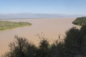
The red or turbid water of Lake Abaya may have turned red due to the influence of the land on which it lies and the local river. This lake, which is un match in terms of width and length among the lakes in the Rift Valley, contains several islands. Among these are Gidicho Island, where the Gidicho ethnic group lives, and the islands in the lake, including Guzuf Aruro, Welegye, Galamaro, Golmaka, and Alkali.

The main rivers that feed the lake are the Blate, Hamasa and Kulufo rivers, while many smaller rivers such as Haren feed the lake. This lake is home to a wide variety of fish species, including crocodiles and hippos. However, fishermen who have worked in the two lakes say that the fish and aquatic life are less diverse than Lake Chamo.
If the lake is provided with boat transport services, it can be a good option for transportation services to Sidama, Hawassa and its surroundings, including Gedeo zone.
