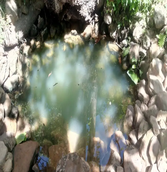
Danduba Fulto /Danduba Source/ spring is located on the road from Zayse Wuzaka to Zayse Dambile. And you will find it at a place called… It is not an exaggeration to say that. So, Danduba spring is the life water of the area that flows year after year in winter and summer. When, It got its name from the name of the area where it is located and it has many benefits. Finally, Beyond being drinking water for humans, animals and birds. Generally, Danduba is a natural spring that springs from under a mountain. Also It is making a significant contribution in terms of protecting the biodiversity and ecology of the area. It is a natural attraction that can be combined with other man-made and natural attractions to make the area a tourist attraction corridor.

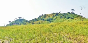
Mogo qaqa / the sample of Sahara desert/
Mogo Kaqa you may be surprise by many things that are not naturally surprising! Mogo kaka is one of this natural blessings. Located in Gamo Zone in Zeise Dembile Kebele, this place is one of the natural attractions in our district. It covers about 20 hectares. This attraction is located at a distance of 74 kilometers from Arba Minch in a sub-kebel with the unique name of Bokola. Seen from a distance, it looks like a pile of sand created by wind power in Barhama area. When you look at it closely, to prove that it is different and very strong. The fact that it has withstood floods and wind erosion for centuries shows its strength.When you look at the place, you can’t take your eyes off it, and you can’t take your eyes off it. It’s a pile of limestone that is name as a mound at the same height. A person who observes from a distance as they go up and down from one to the other will understand that they are playing with nature. For visitors, the place is very suitable for adventurers and tourists who like to admire the unique view of nature. In addition to the fact that Zeise Dembele has a plateau climate. And the wind from Lake Chamo is where it rests. After traveling along the road from Arba Mojan Gidole to Zeise Mekaka. Take the paved road to the north and once you reach Bokola Sub-Kebele. So, you will walk 1 km to reach the attraction.Residents of the area say that before this, the attraction was visit by both domestic and foreign tourists. But they explain that this is not the case at the moment. One of the reasons cited for this is that the road problem is a general problem of Zeise Dembile Kebele. Which is not only a problem for tourism, but also a hindrance to social and economic activity in the area. The road from Zeise Wazaka to Bano is very difficult for making it difficult to reach and visit the attraction. In addition to roads, other infrastructures have not be complete. As well as research and promotion work has not been done.I could observe that Mogo Kaqa has the potential to become an alternative to other attractions. In our district if the infrastructure is developed in the area and it is researched and introduced.
Mount Harura
Mount HaruraMount Harura This place is located in Gamo Gofa Zone, Arbaminc Zurya District, Zeise Elgo Kebele, on the shore of Chamo Lake. The lushness of the area and the presence of the Chamo lake at the foot of it are more than appealing to the eye, as there is no hill or hill in the area except for that mountain. In the morning, the wind and waves rising from Chamo lake, when the wind pushes the water, the steps and steps of the waves that are create as if it wants to catch the one in front of it, when it follows it and misses it, when it rises and falls again, sitting on the hill of the mountain, it does not take away the happiness. At the time when the sun was cooling down to its shelter. The cattle were returning to their shelters with their shepherds. And when they were returning to their shelters individually and in groups. The sound of Lake Samo was over. And all the spectators had left the field. And it seemed to be observing the surroundings in silence Harvest When seen covered with bananas. The European football field looks like green grass. With the green grass of the lake shore and ketema added to it. It seems that life follows its natural cycle. The past generation replaces the present. The present gives birth to the future and walks on the ladder of nature. In the past, people lived on Mount Harura, but they left for various reasons. Currently, the area is desert.If this natural attraction is know, the tourists. Who come to our zone and district can go to the place and visit the biodiversity in the area easily. If this natural attraction is know, the tourists. Who come to our zone and district can go to the place and visit the biodiversity in the area easily.
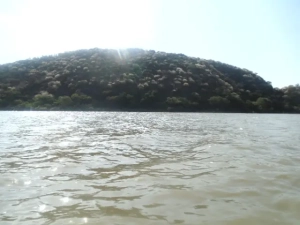
Lake Chamo
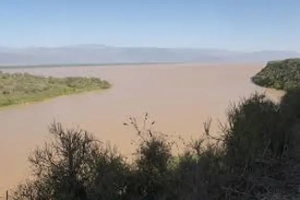
Lake Chamo Located in Arba Minch Zuria Woreda in Gamo Zone, this lake was formed from the many rift valley lakes, which are filles with water 20 million years ago during the Cenozoic Era following the heavy rains that fell on the world during the ‘Pulvian Rains’. After that, the global temperature increased for several years following the rains, and the water level of the lake decreased due to evaporation, which led to its current appearance, according to various researchers. The history of Chamo Lake is not far from this. It can be see that the areas and kebeles covers with land were also part of Chamo Lake. For example, the lower part of Ganta Kanchama Ochole Kebele, Shele Mela, Kola Shele, Zeise Elgo, Zeise Wozeka, and the lowlands of Gumaide and Amaro were coveres by the lake. It is bordered by The Amaro Mountains and Gumaide Hills in the south, the Egzer Bridge in the east, the Bechisar Beherwi Park in the northeast, and Genta Kanchama, Shele Mela, Zeise Algo, and Zeise Wozeka in the northwest. General description of Chamo LakeLength 32 kmWidth (average) 13Total area 317 km²Depth (average) 14 meters The lake contains various fish species, crocodiles, and hippos. Among these, there are various fish species, but only a few are Needs for food due to their taste. The fish species that are most popular and frequently consumed by consumers are koroso (coda), tilapia, white fish (Nile perch), kerkro, barbo and ambaza, according to the lake’s fish consumers and fishermen.Of the fish species listed above, koroso, commonly known as koda, is the most preferred fish species in terms of both price and taste, according to the consumers, fishermen and fishermen. In addition, white fish is relatively larger than other fish species in the lake, weighing up to 80 kg, and its price is also higher than other fish species, according to the consumers, fishermen and fishermen. When you see crocodiles basking on the shores of Lake Chamo in the morning and evening, and the birds trying to feed from the crocodiles’ mouths, you realize how unique the area is. The lake is home to a species of crocodile known as the Nile crocodile. One of which can grow up to 7 meters long and whose skin can be use as foreign currency. The lake serves as a shelter not only for crocodiles and fish, but also for hippos. In addition, many species of birds, including pelicans and flamingos, and crows and egrets, which are found only in Ethiopia, can be found along the shore of the lake.
Lake Abaya
Lake Abaya This lake, which is one of the tourist attractions in the Arba Minch district of Gamo Zone, was forms like any other rift valley lake. Which was forms 20 million years ago during the Cenozoic Era following the heavy rains (Pluvial) that fell on the world. After that, the temperature increased for several years following the rains, and the water level of the lake decreased due to evaporation, according to various researchers. The history of Abaya Lake is not far from this. It can be see that the land-coveres areas and kebeles were part of Abaya Lake. For example, it can be seen that the western Abaya lowland kebeles including Arba Minch Airport, Kolashara, Chano Chalaba, Chano Mile, Lante, Omo Lante, and Ankober were covered by the lake.General description of Lake AbayaLength 60kmWidth (average) 20mkTotal area 1162 sq kmDepth (average) 13.1 mElevation 1285 m The red or turbid water of Lake Abaya may have turned red due to the influence of the land on which it lies and the local river. This lake, which is un match in terms of width and length among the lakes in the Rift Valley, contains several islands. Among these are Gidicho Island, where the Gidicho ethnic group lives, and the islands in the lake, including Guzuf Aruro, Welegye, Galamaro, Golmaka, and Alkali. The main rivers that feed the lake are the Blate, Hamasa and Kulufo rivers, while many smaller rivers such as Haren feed the lake. This lake is home to a wide variety of fish species, including crocodiles and hippos. However, fishermen who have worked in the two lakes say that the fish and aquatic life are less diverse than Lake Chamo.If the lake is provided with boat transport services, it can be a good option for transportation services to Sidama, Hawassa and its surroundings, including Gedeo zone.
Neche Sar National Park
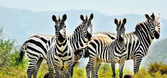
Neche Sar National Park which is one of the national parks in Ethiopia. Is one of the leading tourist destinations in Gamo Zone and Woreda. The Neche Sar National Park, which got its name from the Sar river in it. Is known for its unique natural resources and is very attractive, attracting many foreign and domestic tourists every year.General description of the parkArea 514 sq. km.Water body of the park 15% Abaya and Chamo.Altitude 1108-1650 above sea level.Established in 1966 AD.Mammals 100 species.Birds 351 species.The following are the main natural resources of the Neche Sar National Park.
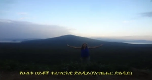
Egzer Dildiye
Egzer Dildiye is a mountain located between the two lakes, Abay and Chamon. The place is located between the two lakes, and its natural setting and topography are attractive. Standing on the top of the mountain, you can see the two lakes to the left and right. The place is a wonderful place to separate the two lakes and serves as a passage to Amaro and Guj from Arbaminch and the surrounding area. This place, which is 1628 meters above sea level, is part of the White Grass National Park.
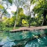
The Forty Springs
The Forty Springs the Famous Spring in Arba Minch. Arba Minch is a natural spring from which the city got its name and also serves as a source of drinking water for the city. Not only because of the many springs in one place. But also because the area is covered in natural forest. It is said to be one of the favorite places visited by tourists in the White Grass Park. Since Arba Minch is close to the city and the area is attractive. It can be seen that the city’s residents go there to relax, swim and have fun. Especially on weekends, the area is crowded with people. The spring water that flows from the water service passes through the surrounding forest. And joins the Kulufon River, ending at the foot of the mountain.
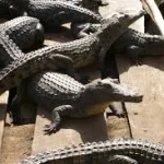
Arba Minch Crocodile Breeding Station
Arba Minch Crocodile Breeding Station which is said to be the only one in East Africa, was established in 1984. With the main objective of utilizing the abundant crocodile resources in Chamo and Lake Abaya. This facility, which has been in operation for many years. It is located 7 km from Arba Minch town in our woreda. And mainly generates a large amount of foreign exchange by exporting crocodile skins to the foreign market. The previous breeding station was flooded by Lake Abaya, and the new facility, which was built in a new form, has created a convenient opportunity for crocodiles to be divided into age groups and raised. The crocodiles are 3 years old and their skin is in demand. As they age, the quality of the skin decreases. This unique crocodile breeding facility in East Africa is visited by many local and foreign tourists.
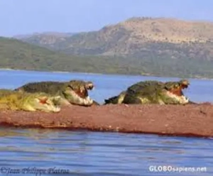
Crocodile Market
The Crocodile Market is located on the shores of Lake Chamo in the White Grass Park region. The Crocodile Market is commonly known as the Crocodile Market because many crocodiles are seen basking on the shore. Crocodiles open their mouths when they are basking in the sun, and watching birds eat the fish meat in their teeth makes us think deeply about the connection between nature. The crocodile in Lake Chamo is a species of crocodile that can grow up to seven meters long.